FAA INFORMATION EFFECTIVE 26 JULY 2012
Location
| FAA Identifier: | OGD |
| Lat/Long: | 41-11-44.3969N / 112-00-46.5725W
41-11.739948N / 112-00.776208W
41.1956658 / -112.0129368
(estimated) |
| Elevation: | 4473 ft. / 1363.4 m (surveyed) |
| Variation: | 14E (1985) |
| From city: | 3 miles SW of OGDEN, UT |
| Time zone: | UTC -6 (UTC -7 during Standard Time) |
| Zip code: | 84067 |
Airport Operations
| Airport use: | Open to the public |
| Activation date: | 12/1941 |
| Sectional chart: | SALT LAKE CITY |
| Control tower: | yes |
| ARTCC: | SALT LAKE CITY CENTER |
| FSS: | CEDAR CITY FLIGHT SERVICE STATION |
| NOTAMs facility: | OGD (NOTAM-D service available) |
| Attendance: | CONTINUOUS
ARPT SFC COND UNMON 2000-0700. |
| Pattern altitude: | TPA 5200 MSL REQD DUE TO INTERFACING TFC FM HILL AFB. |
| Wind indicator: | lighted |
| Segmented circle: | yes |
| Lights: | WHEN ATCT CLSD ACTVT HIRL RY 03/21 & MIRL RY 16/34 & TWY LGTS - CTAF. RY 07/25 NOT AVBL WHEN ATCT CLSD. |
| Beacon: | white-green (lighted land airport)
Operates sunset to sunrise. |
| Fire and rescue: | ARFF index A |
| Airline operations: | CLSD TO ACFT OPNS WITH MORE THAN 30 PSGR SEATS EXCP PPR, MINIMUM 60 MIN NOTICE RQRD, CALL AMGR 801-629-8251/336-7459/710-3706. |
Airport Communications
| CTAF: | 118.7 |
| UNICOM: | 122.95 |
| ATIS: | 125.55 |
| WX ASOS: | PHONE 801-622-5600 |
| OGDEN GROUND: | 121.7 [0700-2000] |
| OGDEN TOWER: | 118.7 253.5 [0700-2000] |
| SALT LAKE CITY APPROACH: | 121.1 |
| SALT LAKE CITY DEPARTURE: | 121.1 |
| BASIC RADAR SVC: | 121.1 |
Nearby radio navigation aids
| VOR radial/distance | | VOR name | | Freq | | Var |
|---|
| OGDr100/4.2 | | OGDEN VORTAC | | 115.70 | | 14E |
| TCHr340/20.8 | | WASATCH VORTAC | | 116.80 | | 16E |
| LHOr166/35.8 | | BRIGHAM CITY VOR/DME | | 112.90 | | 14E |
| LGUr174/39.5 | | LOGAN VOR/DME | | 109.80 | | 16E |
| NDB name | | Hdg/Dist | | Freq | | Var | | ID |
|---|
| BRIGHAM CITY | | 158/19.4 | | 294 | | 13E | | BMC | -... -- -.-. |
| TOOELE | | 010/38.2 | | 371 | | 13E | | TVY | - ...- -.-- |
Airport Services
| Fuel available: | 100 JET-A1+ |
| Parking: | hangars and tiedowns |
| Airframe service: | MAJOR |
| Powerplant service: | MAJOR |
| Bottled oxygen: | NONE |
| Bulk oxygen: | HIGH/LOW |
Runway Information
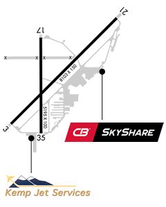
Runway 3/21
| Dimensions: | 8103 x 150 ft. / 2470 x 46 m |
| Surface: | asphalt/grooved, in excellent condition |
| Weight bearing capacity: | | Single wheel: | 75.0 | | Double wheel: | 120.0 | | Double tandem: | ST 152 |
|
| Runway edge lights: | high intensity |
| Runway edge markings: | NSTD NPI MARKINGS, AIMING PTS ARE MISSING. |
| RUNWAY 3 | | RUNWAY 21 |
| Latitude: | 41-11.281505N | | 41-12.227485N |
| Longitude: | 112-01.249282W | | 112-00.004083W |
| Elevation: | 4472.4 ft. | | 4415.5 ft. |
| Gradient: | 0.8% DOWN | | 0.6% UP |
| Traffic pattern: | left | | right |
| Runway heading: | 030 magnetic, 044 true | | 210 magnetic, 224 true |
| Displaced threshold: | no | | 851 ft. |
| Declared distances: | TORA:8103 TODA:8103 ASDA:7252 LDA:7252 | | TORA:8103 TODA:8103 ASDA:8103 LDA:7252 |
| Markings: | precision, in good condition | | NSTD, in good condition |
| Visual slope indicator: | 4-light PAPI on left (3.00 degrees glide path) | | 4-light PAPI on left (3.00 degrees glide path) |
| Approach lights: | MALS: 1,400 foot medium intensity approach lighting system | | |
| Touchdown point: | yes, no lights | | yes, no lights |
| Instrument approach: | ILS/DME | | |
| Obstructions: | 54 ft. trees, 2425 ft. from runway, 305 ft. left of centerline, 44:1 slope to clear | | 24 ft. pole, 1017 ft. from runway, 161 ft. left of centerline, 34:1 slope to clear
+17' ROAD 350' FROM THR. |
Runway 16/34
| Dimensions: | 5195 x 100 ft. / 1583 x 30 m |
| Surface: | asphalt/porous friction courses, in fair condition |
| Weight bearing capacity: | | PCN 63 /F/A/X/T | | Single wheel: | 15.0 |
|
| Runway edge lights: | medium intensity |
| RUNWAY 16 | | RUNWAY 34 |
| Latitude: | 41-12.052903N | | 41-11.197565N |
| Longitude: | 112-00.898063W | | 112-00.894268W |
| Elevation: | 4436.3 ft. | | 4457.2 ft. |
| Gradient: | 0.4% | | 0.4% |
| Traffic pattern: | right | | left |
| Runway heading: | 165 magnetic, 179 true | | 345 magnetic, 359 true |
| Declared distances: | TORA:5195 TODA:5195 ASDA:5195 LDA:5195 | | TORA:5195 TODA:5195 ASDA:5195 LDA:5195 |
| Markings: | basic, in good condition | | basic, in good condition |
| Visual slope indicator: | 2-light PAPI on left (3.00 degrees glide path) | | 2-light PAPI on left (3.00 degrees glide path) |
| Runway end identifier lights: | yes | | yes |
| Touchdown point: | yes, no lights | | yes, no lights |
| Obstructions: | 3 ft. road, 210 ft. from runway, 125 ft. right of centerline, 3:1 slope to clear | | 50 ft. sign, 1200 ft. from runway, 200 ft. right of centerline, 20:1 slope to clear |
Runway 7/25
| Dimensions: | 3618 x 150 ft. / 1103 x 46 m |
| Surface: | asphalt, in poor condition
NUMEROUS LARGE AND DEEP CRACKS, BREAK-OUTS AND RAVELLING |
| Weight bearing capacity: | |
| Runway edge markings: | RYS 07 & 25 MASSIVE CRACK-SEALING HAS OBLITERATED MUCH OF THE MARKING |
| RUNWAY 7 | | RUNWAY 25 |
| Latitude: | 41-11.871662N | | 41-11.872500N |
| Longitude: | 112-01.333198W | | 112-00.544500W |
| Elevation: | 4447.5 ft. | | 4432.0 ft. |
| Gradient: | 0.3% | | 0.4% UP |
| Traffic pattern: | left | | right |
| Runway heading: | 075 magnetic, 089 true | | 255 magnetic, 269 true |
| Declared distances: | TORA:3618 TODA:3618 ASDA:3618 LDA:3618 | | TORA:3618 TODA:3618 ASDA:3618 LDA:3618 |
| Markings: | nonprecision, in poor condition | | basic, in poor condition |
| Visual slope indicator: | 4-box VASI on left (3.50 degrees glide path) | | |
| Runway end identifier lights: | no | | |
| Touchdown point: | yes, no lights | | yes, no lights |
Airport Ownership and Management from official FAA records
| Ownership: | Publicly-owned |
| Owner: | OGDEN CITY CORPORATION
2484 WASHINGTON BLVD
OGDEN, UT 84401
Phone 801-629-8100 |
| Manager: | ROYAL ECCLES
3909 AIRPORT RD.
ODGEN, UT 84405
Phone 801-629-8251 |
Airport Operational Statistics
| Aircraft based on the field: | | 252 | | Single engine airplanes: | | 203 | | Multi engine airplanes: | | 27 | | Jet airplanes: | | 7 | | Helicopters: | | 10 | | Gliders airplanes: | | 2 | | Ultralights: | | 3 |
| |  | |
| Aircraft operations: avg 197/day * | | 66% | local general aviation | | 34% | transient general aviation | | <1% | military | | <1% | commercial | | * for 12-month period ending 31 December 2010 | |
Additional Remarks
| - | NO MULTIPLE APCHS. NO PRACTICE APCHS - FULL STOP LANDINGS ONLY FROM 2200-0700. |
| - | PARACHUTE JUMPING ON NE PORTION OF AIRPORT EAST OF TWY A. |
| - | NO SNOW REMOVAL AFTER ATCT CLOSES. |
| - | HVY VOL OF MILITARY ACFT FLYING OVER OGDEN AIRPORT AT 5700-6300 FT MSL ENROUTE TO HILL AFB. |
Instrument Procedures
NOTE: All procedures below are presented as PDF files. If you need a reader for these files, you should download the free Adobe Reader.NOT FOR NAVIGATION. Please procure official charts for flight.
FAA instrument procedures published for use between 26 July 2012 at 0901Z and 23 August 2012 at 0900Z.
IAPs - Instrument Approach Procedures |
|---|
| ILS OR LOC RWY 03 | |
download (461KB) |
| RNAV (GPS) Y RWY 03 | |
download (374KB) |
| RNAV (GPS) Z RWY 03 | |
download (385KB) |
| VOR/DME RWY 07 | |
download (415KB) |
| NOTE: Special Alternate Minimums apply | |
download (19KB) |
Departure Procedures (Obstacle) |
|---|
| EMONT ONE (OBSTACLE) | |
download (426KB) |
Other nearby airports with instrument procedures:
KHIF - Hill Air Force Base (5 nm SE)
KBMC - Brigham City Airport (22 nm N)
KSLC - Salt Lake City International Airport (24 nm S)
U42 - South Valley Regional Airport (35 nm S)
KLGU - Logan-Cache Airport (36 nm N)
|
|
Road maps at:
MapQuest
MapPoint
Yahoo! Maps
Google
Rand McNally
Satellite photo at:
TerraServer
Virtual Earth
| Aerial photo |
|---|
WARNING: Photo may not be current or correct
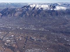
Do you have a better or more recent aerial photo of Ogden-Hinckley Airport that you would like to share? If so, please send us your photo.
|
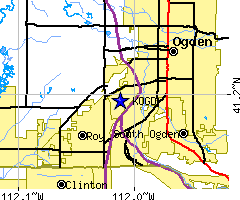
| Sectional chart |
|---|
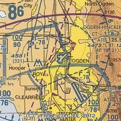
|
CAUTION: Diagram may not be current
 Download PDF
of official airport diagram from the FAA
| Airport distance calculator |
|---|
|
|
| Sunrise and sunset |
|---|
|
Times for 17-Aug-2012
| | Local
(UTC-6) | | Zulu
(UTC) |
|---|
| Morning civil twilight | | 06:12 | | 12:12 |
| Sunrise | | 06:41 | | 12:41 |
| Sunset | | 20:22 | | 02:22 |
| Evening civil twilight | | 20:52 | | 02:52 |
|
| Current date and time |
|---|
| Zulu (UTC) | 18-Aug-2012 03:08:59 |
|---|
| Local (UTC-6) | 17-Aug-2012 21:08:59 |
|---|
|
| METAR |
|---|
| KOGD | 180253Z 00000KT 10SM CLR 28/07 A3003 RMK AO2 SLP106 T02830067 53002
|
KHIF
5nm SE | 180255Z AUTO 00000KT 10SM CLR 26/08 A3007 RMK AO2 SLP070 T02630075 53001
|
|
| TAF |
|---|
| KOGD | 171720Z 1718/1818 16007KT P6SM SCT150 FM172000 29007KT P6SM SCT080 SCT150 FM180400 17007KT P6SM SKC
|
KHIF
5nm SE | 1721/1903 30009KT 9999 FEW150 QNH3002INS BECMG 1803/1804 10012KT 9999 FEW150 QNH3010INS BECMG 1817/1818 30009KT 9999 FEW150 QNH2998INS T33/1723Z T19/1812Z LIMITED METWATCH 1800 TIL 2012
|
|
| NOTAMs |
|---|
NOTAMs are issued by the DoD/FAA and will open in a separate window not controlled by AirNav.
|
|